 Live Music Archive
 Librivox Free Audio
 Metropolitan Museum
 Cleveland Museum of Art
 Internet Arcade
 Console Living Room
 Books to Borrow
 Open Library
 TV News
 Understanding 9/11
tv The Early Show CBS September 30, 2010 7:00am-9:00am EDT
7:00 am

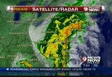
watch. heavy rain from tropical nicole are pounding our area with several inches of rain. we will have traffic in a moment. we begin with howard. he has the forecast. you say this started all the way down in the bahamas? >> this is nicole. she came from cuba. the moisture extends into the bahamas and up the east coast. i think we will end up with 4- 6" of rain in metro and8-10" when the system finally pulls away. you can see the moisture continuing out of eastern north carolina where they had over 20" of rain in the last four days. we had some strong winds and some of the storms along the bay. the west side and east side
7:01 am
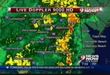
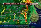
with isolated tornado warnings. we had a lot of very heavy rainfall. live doppler 9000 at this hour is lit up. especially along the bay. new areas are enhancing off to the south and west. we start south and east. we have moderate rain here. heavy is along the bay. out in prince george's county and annapolis and st. mary's. they have been pounded with 4" of rain and tornado warnings. at last check, we did not have any warnings. there is heavy rain from annapolis through shady side and calvert and st. mary's. you head through the district and moderate rain here. we will be dealing with the moderate-to-heavy to torrential rain for another 5-8 hours.
7:02 am
again, looking at charlottesville as well with the heavy rain lifting north. let's go back to the weather computer. let's talk about the weather. all of the counties in green are flood warnings. that is in effect until 10:45. to the north in evan montgomery, up across northern maryland, those go into 12:30. the eastern shore, the flood warnings go into 10:00 a.m. i will tell you these could be extended given the satellite/radar and the amount of water that is still falling from the sky. also, from washington and east, we have a tornado watch until 1:00 p.m. these storms have the potential to rotate. that could produce a short- lived tornado. the bull's-eye will be southeast and southeast of
7:03 am
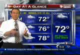
washington. those orange areas are 4-6" of rain. we are talking 6-10" of rain before this wraps up tonight. a lot going on. look at the difference from the 60 degree temperatures in the shenandoah valley to 77 in cambridge. that warm front is helping to turn the winds. we have southeast winds and north/northeast winds in the cool air. that is helping to spin up the storms and aiding for the tornadoes. that is why the tornado watch is in effect. we have 9:00 temperatures around 70 and maybe warm if washington d.c. -- warm in washington d.c. occasional rain and heavy storms gusting over 30 miles an hour. i said it yesterday and this morning. if you can stay home, today would be an excellent way to exercise that option. angie. check out the stack up we
7:04 am

are dealing with on the inner loop of the beltway in maryland. it is caused because of the jackknifed tractor-trailer approaching georgetown road. these drivers are only able to squeeze by using that left shoulder. as a result of that, they are in a solid jam up at river road. let's show you 50 west where we have more problems. this is new. an accident at mlk jr. highway. you have a one hour drive moving it outside northbound on 95 from dale city to the mixing bowl. clearing bumper-to-bumper. that is the only good news there with no accidents. watch for flooding on the inner and outer loop at the 123 exit. you have a good amount of congestion at 95 to 66. as you continue over trying to get to the american legion bridge. we have crash activity. it comes from the dulles toll
7:05 am

road to 67. we know that all of the access lanes are blocked. it is taking away one lane on the left side. drivers here are pretty much stacked at hunter mill. back to you. thank you. you heard it from howard and devin. we are under a flood watch until 9:00 p.m. flooding during a downpour is a concern in alexandria. we have jessica from old town along king street. >> reporter: good morning. we are at the very end of king street where it terminates at the potomac. i want to show you the scene. you will see boats out there. if you don't mind the rain. it is a pretty morning here. the potomac is still and calm except for the rain. the concern today will be at high tide. that comes at 1:25 today. the concern is the sun will
7:06 am

rise and it will jump the bank. angie was talking about the one- hour delay on the roads because of the puddles that have formed. this is the old dominion boat club. lots of boats are out there resting comfortably in the water. we have the down spout to give you a sense of how quickly this water is coming out. there are no sand bags at this particular location at the old dominion boat club. this is the scene in alexandria here on king street. we have not seen any businesses out with sand bags. if you live in this area, you can pick up sand bags at king street and lee street. you have to bring proof of residency to get a handle of the bags. we will watch the conditions
7:07 am

here. back to you. >> thank you. our live team coverage of the stormy weather continues kristin fisher. she joins us with more on conditions to the west. even the gortex hasn't prevented you from getting soaked to the bone. >> reporter: it would be worse if i did not have the gortex on. it is completely deserted. there is nobody out here, which is good. we want people to stay inside, if possible, until the worst part of the rain is over. we have been listening to angie and jessica and everybody talk about the traffic building up on the roads. especially as you get closer into washington d.c. out here in louden county, i warrant you to look at the -- i want you to look at the
7:08 am

leesburg pike. we have been watching this all morning long. we have not seen one single tie up on route 7 throughout the morning. great news there. we want to caution drivers to plan for extra time this morning. these roads are slick. as jessica was saying, there are big puddles. watch out there. so far, so good on route 7 heading into dc. down here, this is goose creek. we have been watching this throughout the morning to monitor the situation there and see if there is any danger of flooding. you can see the creek is still well within its banks. the water is a little bit rough. that is a slight concern there. in terms of flooding, no major issues here. right here, no big problems to report. i will say one thing we have been out here throughout the morning and we have seen
7:09 am

kayakers out here. they love seeing these conditions on goose creek. they are planning on monitoring these conditions throughout the day. when it stops raining, they will head out and enjoy kayaking. the rain is great for farmers and kayakers, but not good for the drivers. back to you. >> thank you. i never thought about the kayakers. stay with us all morning long for continuing coverage of the storm alert. we will be with you for a few more hours bringing you live weather and traffic updates. e-mail us your pictures to photos@wusa9.com. you can e-mail them to us on our facebook page. you can tweet your pictures as well. we will get them on air. our coverage of the weather continues. before we head to break, here is one more thing from howard.
7:10 am

>> watching tremendous rainfall east and southeast of town. light-to-moderate rain and more heavy rain on the way. lots of yellow and orange and red. we will update the forecast for the weekend when we return. chevy chase bank is becoming capital one bank.
7:11 am

with the most locations in the dc area, we figured they could use our help. ♪ down a bit. too much. [ crowd cheering ] [ grunts ] [ garth ] capital one bank. now with the most branches and atms in the dc area. what's in your wallet? welcome back. it is a tough drive from gale city to the mixing bowl. you are looking at a drive time of one hour. more road conditions and flooding spots to avoid coming
7:12 am

up. and joining us right now with road conditions in maryland is kelly from the maryland state highway administration. >> good morning. >> how will it be for drivers heading out on maryland highways? >> for you heading out, we are dealing with severe storms today. we want you to be aware of the potential for signal outages or downed trees. we don't have closures to speak of, but we have high water on the secondary routes. we want you to hone in on the basic rules of the road. >> we heard there may be some standing water on the exit ramps and entrance ramps to the bridges. is that where you are seeing some ponding of water? >> we are mainly seeing it on
7:13 am

our secondary routes. you have lane reductions near montgomery street. for you heading out and you are used to having two or three travel lanes, you may see water on the shoulder. be prepared for lane reductions and always prepare for a signal outage. we are expecting a lot of rain throughout the course of the day. our crews will be out where we need to be. we want you to stay alert for any downed trees. >> your crews have been on alert since yesterday afternoon with that terrible bus crash along 270 and knowing that this storm was going to be approaching. >> yes. we were getting ready and making sure we have everything available to be responsible for clearing trees and drains. we wanted to prepare for the storm. we will be out today as well. >> any other good advice for drivers who are preparing to
7:14 am

leave their homes going to school or work? >> plan extra time. >> thank you, kelly. 9 news coverage of the weather continues. howard has another update for us. we are watching flood warnings and torrential rain and a tornado watch. no tornado warnings. we will break it all down for you. the storm reports with devin when we return. guys, go get changed! ...or soccer practice, it's important to be prepared for dinner. that's why i've prepared my perdue perfect po fresh chicken breasts. they're individually wrapped, so you can cook what you need and store what you don't. we're not playing helicopter now. ready when you are, they're trimmed of fat and consistently sized to cook in just 10 minutes. life's not perfect. that's why there's perdue perfect portions. [ male announcer ] perdue perfect portions. ready when you are.

7:16 am

capital one bank. they're everywhere. yeah, you're right! ♪ [ male announcer ] capital one banks are everywhere. [ clang! ] with hundreds of branches and atms, they're hard to miss.
7:17 am

hey, there's one right up the street. [ male announcer ] capital one bank. the most branches and atms in the dc area. what's in your wallet? ove, go long! welcome back to 9news now. 7:17. this is a live look at the roads in the area. a lot more of you are out on the roads trying to get to work or school. leave yourself enough room between the car in front of you and be patient. we are under a flood watch until 9:00 p.m. tonight. we will be here all morning long to get you through the early part of the storm. our live team coverage of the weather continues now with scott broom.
7:18 am

he joins us from annapolis, maryland with a look at what is to the east of us. good morning, scott. >> reporter: good morning. you are looking at a live web cam out of the front dash of my car. i'm speaking to you hands free on my cell. this is route 450 west of annapolis. i don't need the satellite/radar to let you know it is pounding rain here east of the dc area. as howard as told us all morning. west street. this is route 450. the left lane is not usable because there is so much water in the gutters and it is pounding on us. there will be significant issues this morning. i have seen school buses out. people are getting up and doing the best they can to move forward with the day. they will get on the roads and see the water in this section of annapolis and on into prince
7:19 am

george's county in bowie. i'm about to get on route 50. the ponding water on the roadway and the inability to use the right lane because of the amount of water that is in the gutter that is the big issue this morning. it goes without saying that headlights are mandatory. if you have old windshield wipers leaving streaks, figure out how to change them quickly or don't go out at all. >> find a store for that. >> reporter: that is right. i'll move on to route 50 now. it is good to talk to you. i'll stay in touch as the morning unfolds. people are moving. moving slowly with reduced visibility and lots of ponding water on the roads. >> scott, your signal is going
7:20 am

in and out on the beltway. as he says, the right lane may be removed because of ponding water. take it slowly on the roads. we go from that area of route 50 to greg. he joins us live from fairfax county where first responders have made a swift water rescue. what else can you tell us? >> reporter: it was about 45 minutes ago that fairfax county and fire and rescue and swift water rescuers waded in using a boat to this water, which is probably 4-5 feet above a bridge on woodburn road. we are about a mile southwest of fairfax hospital. this is an area that traditionally floods. these rescuers pulled two people from the vehicle that you are looking at right now. they dried them off and got them out of here, but their vehicle remains in the flooded
7:21 am
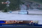
highway or flooded road. this is a busy road most mornings. it is a small country road. it is a cut through from west annandale. it is closed off and barricaded today. one vehicle is in the middle of the road surrounded by three-to- four feet of quickly moving flood water from the creek. you can see the movement of the water past the car. you can see that it doesn't take a lot of water to really create a very dangerous situation. it is moving quickly. you can see how quickly that car may have been surrounded. the bridge that crosses the creek is totally submerged in the water. you know, we are lucky they got these folks out. one question, i guess, begs to
7:22 am

be answered. was this road barricaded? were there cones up? were there signs up? i do not know whether this driver circumvented the cones and signs. clearly, either way, the answer is they could not get through here. >> they are not getting through. luckily they were rescued. this is greg. he is in northern virginia bringing us the story of the swift-water rescue. maybe it was dark at the time they were in there. if you cannot see the road, turn around. look how high that was up to the door? >> this water cut the engine out. it takes two feet of rushing water to push a car off the road. 6" of rushing water can knock you down. this is where greg is located in annandale. we have other scenes like this,
7:23 am

i'm sure, where you have streams and creeks. you can see on the left area where the waves from the rushing water lapping at the shore line as the creek is expanding as the rushing waters were flowing downhill. >> look at that picture and make sure you don't replicate it. we don't want to hear anymore swift-water rescues because you did not follow the rule. turn around, don't drown. >> we will see more streams and creeks that will become impassible during the morning hours. especially during the afternoon. i still think we have another 5- to-8 hours of moderate-to-heavy rainfall. this is streaming off the atlantic. that red box is a tornado watch. this is not a true tropical system. you have tornadic thunderstorms. we have seen that this morning
7:24 am
especially in the carolinas and southeast virginia. we had a little of that here. you see that one deep red band now from southern maryland to the eastern shore. lots of moderate-to-heavy rain. live doppler 9000. we have moderate rain across the area. look at the deep pockets of red off to the east. you saw scott broom in annapolis. it is on the eastern shore across the bay bridge. if scott takes the trip across that, and i don't recommend that, because the eastern shore is hit hard. let's zoom in at washington and bwi. there have been many flight cancellations. torrential rain north of severna park. on the east side of baltimore. here is annapolis. shady side and over to queens town. this is dumping buckets of rain
7:25 am
in the range of 1-2" or 3" per hour rainfall rates. we will go farther south down into copper county. st. michael's, you are dealing with a heavy shower there. potentially heavy wind. beyond the tornado watch area, we have a potential to spin up and rotate. we have st. leonard with the moderate rain off the eastern shore. st. mary's city, look at the lift north. the torrential rain continuing there. charles county, we have moderate rain there. look off to the south here. north and east of ashland. this is moving north to you. you have moderate rain now, but the heavy rain will return in another 30 or 45 minutes. there is a lot going on. let's move forward on the weather computer. we have flash flood warnings for just about everybody.
7:26 am
from 10:00 a.m. to noon. we have the tornado watch until 1:00 p.m. off from the metro to points east and southeast. it is more stable to the west because the air is cooler. the southeast push. a coastal flood advisory for all of these folks. the potomac and chesapeake and tide is moving 1-2' above normal. we had many reports of severe weather coming in. devin has more on that from the weather terrace. >> i'm here outside, howard. i don't know if we mentioned this north of chevy chase and wisconsin avenue, that is closed this morning. southern parts of maryland, we have many closings and flash flood warnings. if this rain continues to fall, you need to be aware. you can go to wusa9.com and click on storm reports.
7:27 am

you will get the storm reports that come into me. i have seen the storm reports in southern maryland. you will send your photos at photos@wusa9.com. e-mail those in and we will have the latest with that. angie, let's talk about traffic. let's talk about the big headache of the morning. old georgetown road is the scene of the accident involving the jackknifed tractor-trailer. this, my friends, this is what it is causing. one stack up that starts before the dulles toll road trying to get past the accident scene. it is moving slowly because these drivers here will have to squeeze in. they can only get by with one lane. it is the left shoulder. that will be with us for some time. let's take it over to the toll road east. past wheelie.
7:28 am

we have more blocking the access lanes. 66 headed east, you are slow from 234 to 295. stay with us at wusa9.com. click on the traffic banner. that is where i have all of the flooding spots to avoid this morning. 7:28. we have more traffic, weather and news when 9news now returns. in case of everyday emergencies, it's important to be prepared for dinner. that's why i've prepared my perdue perfect portions fresh chicken breasts. they're individually wrapped, so you can cook what you need and store what you don't. [ male announcer ] perdue perfect portions. ready when you are.


7:31 am

♪ ♪ [ female announcer ] bursting with mouth-watering real fruit and refreshingly blended with creamy, low-fat yogurt. mcdonald's new strawberry banana and wildberry smoothies are 100% pure sipping fun. the simple joy of real fruit smoothies. ♪ i do 22 more inspections than the government requires. and my fresh, all-natural chickens are never given any hormones or steroids. ♪ ...and no candy, gladys. [ clucks ] [ male announcer ] perdue. extra inspections... extraordinary chicken.
7:32 am

good morning. welcome back to 9news now. thank you for joining us this morning for extended coverage of the weather alert. angie has been busy in the traffic center. she has more to tell you, but howard starts us off because it is the trickle down from the rain that is falling down. >> this is more than a trickle. we have rain totals 6.5". route 244 closed in leonardtown. we heard about weather-related issues. i want to start with the weather computer. the rain continues with the tropical rains. this moisture, this plume of water coming in from north of
7:33 am

the bahamas now through east of north carolina. some areas have had over 2' of rain in the last couple of days. we have 6" and growing. we have moderate-to-heavy rain in areas. the heavy rain from warrenton to culpeper. to our east, this is where they have been hit the hardest. annapolis up to baltimore. you see the heavy rain along the bay. across the eastern shore in tillman and st. michael. it comes back to st. mary's county. you are seeing the torrential rain tropical downpours. that extends to the northern neck as well. this is all lifting off to the north. some of the cells are moving 40 miles an hour or more. if anything spins up, it will happen quickly. let's go back to the weather computer. we will talk about the weather.
7:34 am
all of the counties in light green are flash flood warnings. be careful. stay home if you can. it is that simple. everybody else, flash flood watch until 9:00 p.m. tonight. right now, we do not have any warnings. however, the rain totals that we are looking at through the storm, the orange colors are 4" plus. the yellow color is indicating 7-8" totals. a terrible rain event going on right now. 7:34. let's find out about the terrible traffic of the. thank you. if you -- terrible traffic. thank you. if you are not used to the rainy conditions, you need to give yourself extra time and space. across the american legion bridge is taking you 45 minutes because we have the jackknifed
7:35 am

tractor-trailer at old georgetown road. drivers are squeezing by using one lane on the left shoulder. the outer loop is doing fine. taking you over to the map. i want to show you this at university boulevard and burnet avenue. we have flooding conditions that has roads closed at beach drive. it is closed at franklin. 355, another road closure. it is impossible to get all of the standing water reports crammed into the report. we have them posted on wusa9.com. 95 northbound in virginia, it is taking you one hour to get up to the mixing bowl. the wet weather conditions adds to that. back to you. thank you. howard calls it torrential tropical downpours. the flood watch is in effect until 9:00 p.m. we want to look at conditions
7:36 am

in alexandria, virginia. jessica joins us live from old town. >> reporter: it is still coming down here in old town alexandria. it will keep coming down. we are being treated to a light rain. the sun has come up. we have daylight or at least overcast daylight. we have seen torrential downpours this morning. let me show you the scene on old town alexandria. we want to let you know that you can pick up sand bags at king and lee streets. bring proof of residence to pick up the sand bags. this around is called my thai. you will notice no sand bags. this is the situation we see all up and down king street. this is the low-lying area of old town alexandria. there is a 20-swath block that tends to get flooded when the potomac jumps its banks.
7:37 am

there are lots of puddles. people are walking their dogs and enjoying the life in the morning in rain gear. obviously we have the potomac over here. the concerns are high tide comes to us at 1:25 today. with the amount of rain, the potomac could jump its banks. we had the indication that it could rise 5" to 2-3' with some expectations. back to you. >> thank you very much. our live team coverage of the weather continues with kristin. she joins us live from goose creek in louden county. you told us earlier that goose creek's flood stage is 12'. nowhere near that this morning with the downpour, correct? >> reporter: absolutely. we have been out here for four hours now. during that four-hour time
7:38 am

period, we watched goose creek rise 2". this is goose creek outside of leesburg in louden county right under route 7. the water is churning. it has been, if you can call it white water, the roughness in the water has been picking up throughout the morning. nothing terrible. right now, the river is at 1.4'. when we got here this morning at 3:30 or 4:00, it was at 1.2'. the river has gone up 2" since we have been out here. it is expected to crest at 5.4' tomorrow morning. 5.4' is nothing for goose creek. this river is not expected to go out of its banks. there are dangers or concerns of flooding farther down stream
7:39 am
in the lower lying areas. for this section here outside of leesburg, no eminent danger. people are trying to get on the roads early and get to work because we have been listening all morning. we know how bad traffic is in some parts. for rear along route 7, so far, so good. bring out the umbrella. it is not too bad. back to you. >> thank you. not bad right now. get back in the truck and stay dry. stay with 9news now all morning long for continuing coverage of the storm alert. we will be with you for a few more hours bringing you live weather and traffic updates. we would like to know how the rain storm is affecting you. e-mail us your pictures to photos@wusa9.com or post them on our facebook page. facebook.com/channel9.
7:40 am

our coverage continues after this. before we head to break, here is howard with another update. we are looking at the rains continuing to come down. some totals in excess of 6". we have more rain to go. devin will join me. we will have the storm reports and tell you where the rain is located and when it will finally get out of here. 9news now will return with the extended edition after this break. did you know
7:41 am

go-gurt is specially made to freeze and thaw by lunch time? so kids can have their favorite yogurt in their lunch box
7:42 am

go-gurt. freeze it. thaw it. eat it up. ¿qué si usamos tacos más grandes? [ male announcer ] old el paso super stuffers. 33% larger shells. feed your fiesta. in case of everyday emergencies... guys, go get changed! ...or soccer practice, it's important to be prepared for dinner. that's why i've prepared my perdue perfect portions fresh chicken breasts. they're individually wrapped, so you can cook what you need and store what you don't. we're not playing helicopter now. ready when you are, they're trimmed of fat and consistently sized to cook in just 10 minutes. life's not perfect. that's why there's perdue perfect portions. [ male announcer ] perdue perfect portions. ready when you are.
7:43 am

and not what you get? like electricity for gadget power at your seat. room to stretch your legs, and your wingspan, food when you're hungry, and taking off your shoes, only if you feel like it. these aren't luxuries, they're basics. get them back on acela. but you wouldn't want an antique computer. or an antique tv. ♪
7:44 am

or an antique remote control. so why are you still using an antique cable network created in 1948 for your 2010 tv? it's time to hook your tv up to a 100% fiber optic network. it's time for fios. visit verizon.com/getfios. call the verizon center for customers with disabilities at 800-974-6006 tty/v. at 7:44, we have breaking news from silver spring, maryland. two metrobuss have been -- buses have been involved in an accident at silver spring. there are 10 injured people being evacuated for minor injuries. we will have more on this story and our continuing coverage -- chief garcia, are you there? >> yes, i am.
7:45 am

>> very good. >> it is captain garcia. >> thank you very much for being with us. update us on the two metrobuses that have collided near the four corners area. >> we were called out shortly after 7:00 a.m. at university boulevard west of burnet avenue. we have two buses involved. we were evaluating 10 individuals on the bus. the number has risen up to 19. they are being evaluated and transported to local hospitals. we have different areas of treatment and transport areas. we have contacted most of the local hospitals to take them. in regards to injuries, all are minor in nature, associated with aches and pains. no traumatic injuries associated at this point. we have over two dozen personnel on the scene. >> that is what we are looking at right now on the cameras.
7:46 am
we see lots of flashing lights. would you attribute this to the dangerous road conditions this morning? >> we have been experiencing a number of collisions throughout montgomery county. obviously, it has been raining for a bit. we are encouraging all drivers to take it slower and keep your distance between vehicles. we don't know the circumstances of the particular collision. we have been busy with the weather. >> as we look at the camera shot, we see cars approaching it, but can they get through at this area or is it completely blocked off? >> at this point, some cars are being led through the incident. however, we will shutdown all lanes as we transport of the units. we are in the process of moving the vehicles through the scene to let emergency transport to get to the hospital. that will be shutdown while we get units in place.
7:47 am

>> captain garcia from the montgomery county fire and ems updating us on the collision of the two metrobuses in the area of silver spring. an update now. 19 people have been taken to area hospitals for observations. early assessment is minor injuries. 9news now coverage of the weather continues. howard, do you have anything else besides the falling rain? lots of falling rain. we are looking at really heavy rain across the area. the heavy is east of town. we have many hours still that we can deal with moderate-to- heavy rainfall. a potential for continued and expanded flooding. devin joins when for the full forecast coming up.


7:50 am

7:51. welcome back to 9news now and our special coverage of the weather alert. this is montgomery county and university boulevard and burnet
7:51 am

street. the flashing lights are all the units responding to the collision of two metrobuses due to the slippery road conditions. we just heard from captain oscar garcia of the montgomery county ems that 19 people were transported to hospitals for observation and check ups. the traffic is starting to build up in that area. very few cars are able to get by to one side. be prepared if you are headed in the area of university boulevard and burnet street. you may need to find an alternate route. >> be prepared for delays. >> howard has his sleeves rolled up. he is working hard. we have reports now. devin will have them for us in a moment. some rain totals in excess of 6" in southern maryland. 1-4" here in the metro area. several more inches of rain is
7:52 am

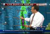
expected. that is why flooding and topper and i have been talking about this the last several days. it is a real threat. we will go to the weather computer and go to doppler. we have seen a back edge of this system in southwestern virginia and northwestern north carolina. this goes offshore for a few hundred miles off the north carolina coast. we could have this fire hose of tropical moisture on top of us for a good six or eight hours or longer from where we are right now. let's go to doppler 9000. we will pinpoint the worst of it. you see it east and south. we have light-to-moderate rain coming in to the shenandoah valley. a couple of inches in southwestern areas. we have some reports out to the west. it has been spinning east.
7:53 am
right now, it has been across the bay. calvert county is under water with 4-6" of rain. north beach down to st. leonard and st. mary's county. check how this is moving south- to-north. it is staying outside the beltway. anne arundel will get it. this is moving north. this is going to come into stafford and prince william over the next hour or two as it lifts north. that is creating all sorts of problems. back on the weather computer. let's talk about the problems. we have flood warnings. the green is shaded for rain. these flood advisories are until 10:30 and noon up north. don't be surprised to see the flood warnings extended into the afternoon.
7:54 am
we have severe weather. for the metro and points east and southeast, a tornado watch is in effect until 1:00 p.m. this is typical of landfalling tropical systems. this is moving west like isabelle, but it is a lot weaker. high tide is 1:25. temperatures climbing through the 70s. out to the west, you will hold to the 60s. the winds gusting to 30. here is the cooler air with the northerly winds. this is helping to give more spin. devin joins us from the weather terrace with damp conditions. we had a lot of storm reports. >> this is starting to fill in. brandy wine with 3.14". they had a lull.
7:55 am

wood bridge with 3.9" of rain. 4" up in montgomery county. 6.5"" at the paxtuet river. i have been told by some people the bridge is closed. keep your photos coming to us at photos@wusa9.com. >> we will go to angie with latest on the roads. this picture speaks for itself. look at this. east university at burnette street. all lanes blocked because of the accident with two metrobuses. they are able to squeeze by with one lane to the right. the inner loop is still a big mess. let's take you there.
7:56 am

we are stacked from 66 making your way to 270 spur. that is because we have that jackknifed tractor-trailer at old georgetown road. as a result of that, only one lane of traffic is squeezing by on the left shoulder. this is going to be a big headache for a lot of people. 66 delayed here for 30 minutes to the beltway. a lot of flooding spots to avoid. morning side is closed. 9news now will be right back.
7:57 am

it's important to be prepared for dinner. that's why i've prepared my perdue perfect portions fresh chicken breasts. they're individually wrapped, so you can cook what you need and store what you don't. [ male announcer ] perdue perfect portions. ready when you are.

7:59 am

i do 22 more inspections than the government requires. and my fresh, all-natural chickens are never given any hormones or steroids. ♪ ...and no candy, gladys. [ clucks ] [ male announcer ] perdue. extra inspections... extraordinary chicken. good morning. you're watching extended weather coverage now. we've been with you since 4:00 a.m. we'll be with you for a few more hours. we're always with you on
8:00 am

www.wusa9.com. angie will have traffic in a moment. right now, a quick look at forecast. >> down in st. mary's county we have 6.5. we have flooding across the region, which is occurring and getting worse. i think they'll be here throughout the afternoon. we thank you for your reports. you can go to facebook.com or just e-mail me here. we're happy to -- >> you'll be flooded with e- mails. >> for sure. let's start you off. i want to tell you this moisture continues to stream in off the atlantic through north carolina through virginia. you're see egg that curly-q there. that's an area of low pressure north of raleigh now. as it passes, it will shut off
8:01 am
the rains to the west. the rains metro and east, we got get that flow off the atlantic to stop. right now, that is well established and looks like it will be here for quite some time. i'm thinking at least another six hours, at least. maybe double that. we've already had anywhere from one-six inches. you get the idea. we have a lot more rain, many more inchings of rain to fall. we do see moderate rain in most of the area. starting to see more yellow showing up forward northern virginia. the shenandoah valley. here in the metro, we have the moderate rain shower, but they become heavy in eastern charles. our friends in charles county, rain picking up for you. across the bay, over toward queenstown and chestertown, very heavy rainfall. some of those rain rates are
8:02 am

one-two inches per hour or more. i understand that the north beach area, those roads right by the bay are all under water right now with flood warnings continuing right now. look at the heavy rains down around st. mary's city. this continues to stream north, so our friends in reedville, expecting you to monopoly with an impressive total. it just keeps coming. that is causing all sorts of problems. we've talked about other roads that are under water. we'll show you those flood warnings currently in effect from the eastern half of virginia through the bay. out toward marshall and manassas. up north. all of these areas, flash flood
8:03 am
warnings. the flooding is happening. a tornado watch in effect. that storm has been moving north at about 40 or 50 miles an hour. as far as the rainfall, we're still thinking some areas could exceed eight to ten inches before this storm is done. temperatures now, 72. they'll climb into the upper 70s. we get better tonight as the rain tapers to shower, but it will be a long, wet day. now over to angie. >> thank you. right now, we begin with a traffic alert. this accident involved two metro buses has westbound university boulevard totally shut down. notice the eastbound traffic is stacking up a bit but still getting by. following police direction, they're able to squeeze by. now over to the interloop from
8:04 am
66. one big, solid jamup. could take you more than an hour. that's because we have that jackknifed tractor trailer. these drivers are getting by only on the left lane. 270 headed southbound, new accident to report. this is at shady grove. it's in the local lanes. as a result of that, we're seeing an add up to the backup on 121. northbound on virginia, it's a crawl from the car rest area up towards the mixing bowl. that stackup only continues once you approach 395 and make your way from the beltway toward the 14th street bridge. >> all right. thank you. u.s. park police officers are also handling a bunch of weather-related problems. sergeant david slosher is on the phone now.
8:05 am

where are the big problems this morning? >> right now we seem to be good without too many air problems in our areas. we have anticipating flooding. >> i noticed this morning on my way in to work, there were barricades up along beach drive near rock creek park. last time there was flash flooding there, it spilled over the runways. you were extra proactive about this storm given the notice. >> i think the important thing to note is flooded roads are responsible for 50% of all flood-related deaths happening in vehicles. when you see roadways that are closed down with barricades, do not drive around the barricades. roadways can be washed out. you can get swept away in your car. they can be fatal. >> again, you're saying you're not seeing the kind of problems that you had during the latter part of the summer, but have you made any calls? have people been stalled out on the roadwayings this morning?
8:06 am

>> we've had a couple crashes and a couple cars become disabled. fortunately, we haven't been hit too hard. seems like montgomery county is getting the brunt of it right now. >> well, we hope you have a slow morning. that means people aren't getting involved in rescues or serious crashes. thank you for speaking with us. >> all right. you have a good day, and drive carefully. >> all right. i will. there's a high tide coming in alexandria, virginia. that could cause a lot of flooding. that's where we find jessica doyle. good morning. what time is high tide scheduled? >> reporter: right now is low tide. we're at height of low tide. i just jumped the bank over here. i jumped this barricade over here to take a look at potomac level. we have about two feet before it could potentially crest.
8:07 am

here's the situation. high tide comes in about 1:00, 1:20 this afternoon. it's going to rise about two feet, typically. but we have gotten so much extra water coming in from this storm, it could rise an extra five inches to two extra feet. that could spell problems here in oldtown alexandria. this section is regularly flooded. the potomac jumps the back. lots of businesses around this area. lots of people who live here. they know when the rain come, it's time to sandbag. as a result, old town alexandria is offering sandbags for folks who live in the area. you can get your sandbags at king street and lee street. be sure to come with proof of residency because they're not just going to hand these out. this area here, i just came over. this area is pretty much at level with the potomac.
8:08 am

you see the issue. when the tidal wave comes over and jumps the bank, it just spills out through this area and can completely cover this part of old town alexandria. there's about 20 block stretch that typically faces problems. there have been four historic floodings in this area over the last 20 years and regularly smaller floodings. definitely something we're going to don't watch for you here. the rain starting to pick up a little bit. kind of at a moderate clip right now. we've seen it nearly taper off this morning. we've also seen it come down in buckets. we're going to continue to watch the situation here for you. with that, we'll send it back to you. >> jessica, thank you very much. when we come back, we'll have more on our weather alert. it's 9 after the hour.

8:10 am

welcome back. our time is 8:10. we have other news for you this morning. the flyover beltway reopened overnight. this after that dead by bus accident yesterday afternoon. that snarled rush hour traffic for hours. a tour bus headed back to pennsylvania plunged off that ramp. >> investigators do not believe this vehicle was airborne, so it was not a 45-foot drop through the air. they believe the vehicle was in
8:11 am

contact with the ground the entire way. >> the bus driver was killed. 12 passengers, including at least four children were injured. most were taken to suburban hospital. all are expected to recover. also, two cars collided when the bus wrecked right in front of them, injuring one person. this team of investigators will also look into the cause of the crash. investigators have termed yesterday's deadly fire in northwest washington as suspicious. flames ripped through the eight- story apartment building in columbia heights. two men tried to jump to safety using a telephone cord and a tree just outside the building. one man missed the tree and fell to the ground. he later died. now we want to get to the latest on the serious accident in silver spring this morning.
8:12 am

captain oscar garcia with montgomery fire and rescue joins us live. this happened around university boulevard and brunett streets? >> yes. >> tell us about two metro buses. >> initially, information appears to be it was a collision of two metro buses. we are still evaluating. we've transported at least half of the occupants of these buses to the local hospital. there are probably some high school-aged children on the bus. probably taking the bus to a nearby high school there. we're anticipating possibly going to the high school -- [ indiscernible ] all injuries this point are deemed minor and not life threatening. >> and you had told us a few minutes before that maybe as
8:13 am

many as 19 people had been transported to the hospital. is that the same number still, or has it increased or decreased? >> actually, that number is still accurate in regards to transported. we're in the process of transporting 13 on our medical ambulance bus. that bus holds well over 20 patients. we're planning on transporting most in that. >> we're looking at a live picture of this scene near silver spring. we see a lot of flashing lights. how many of your people responded to this accident? >> actually, right now we're close to two dozen fire and rescue personnel including a number of transported units along with our medical ambulance bus and medical support unit, which pretty much
8:14 am

has extra emt equipment. >> over the last few hour, you and your crew have been put to the test with this accident here this morning and yesterday at i-270. >> yeah, we have. we train pretty regularly for mass casualty incidents. unfortunately, it has happened, but we're trained and prepared to respond. we just ask folks to slow down. hopefully these incidents will decrease. >> okay. but you have seen other little accidents this morning probably due to the slick road conditions. >> that's right. we have responded to a number of these accidents throughout the county. they're minor in nature. no traumatic injuries at this point. they are continues, but we're hoping that folks slow down and they decrease. >> thank you for speaking with 9 news. while we're starting to count how many inches of rain we're going to get, the totals are already approaching two feet in some places to our
8:15 am

south. here's howard. >> flash flood warnings continue to expand. we'll update you on that. also, the radar is all lit up. the rain continues. the flooding continues. your full forecast in just a moment. in case of everyday emergencies, it's important to be prepared for dinner. that's why i've prepared my perdue perfect portions fresh chicken breasts. they're individually wrapped, so you can cook what you need and store what you don't. [ male announcer ] perdue perfect portions. ready when you are.


8:18 am

i do 22 more inspections than the government requires. and my fresh, all-natural chickens are never given any hormones or steroids. ♪ ...and no candy, gladys. [ clucks ] [ male announcer ] perdue. extra inspections... extraordinary chicken. welcome back to 9 news now. rainfall totals could be even higher in parts of the carolina than they will be around washington. some parts of eastern north carolina have already recorded rain totals over 20 inches. many roads there are already closed. at least one mobile home park has been evacuated. thank you for tuning into in extended edition of 9 news now. howard is here. boy, it's just what you predicted yesterday. >> thank you. you think about tropical storm alicia in houston.
8:19 am

that one sat there. this one is moving and we're still getting high totals. we have flood warningings that have been expanded. i want to start with the big picture though. show you the rain continues to pour in off the atlantic. we have some moderate to heavy rain in many, many areas. this is tropical stuff. rainfall at about an inch or two an hour. it is piling up. let's show you the warnings. all these counties in green are under flash flood warnings. that new one off to the west, just west of culpepper, that's nelson and green counties. that goes until 2:15. just a lot of rain, and it's going to continue to be heavy. let's go to the radar. while we have a lot of green,
8:20 am

yellow is increasing to our south and west now. you see those heavier rain showers moving in. still, it's the east and southeast getting the brunt of the rain. here in washington, inside the beltway, you see heavy, heavy rain. north beach, got reports that many of the roads are under water at this hour. torrential, torrential rains. even kent county, a tornado warn going on until 9:45. this is going to head right up route one here and get over toward national airport in another 20 minutes. even winchester and parts of west virginia, you're getting very heavy rainfall right now.
8:21 am
did you see this coming from charles county, virginia? we have flood warnings. it's happening. roads are closed. water continues to rise. remember, it's raining. anything that's high now will only get higher. back on the weather computer, we have a tornadic threat. we talked about kent county here for another 25 minutes. this is the baltimore tv market, headed toward the upper part of the chesapeake bay. the metro, east, south, we have tornado watch until 1:00. the concern is some of the storms coming out of the northern neck could be spinners as well. coastal flooding as well. winds are gusting over 30 miles an hour. tides one to three feet above normal. the counties in the light green are for coastal flood advisories. we'll have one to two foot high tides there. even in the delaware bay there.
8:22 am
this storm is passing to the west. temperatures today, starting in the 70s with very heavy rain at times. east to southeast winds from 10- 20. devin has been with me all morning. >> just incredible. totals already starting to come in. it's a steady, light rain here in the northwest. three and a half inches of rain in owings. brandy wine, that's the southeast part of the metro, 3.5 inches of rain nearly there. back over to northern west virginia, 2 inches of rain where they've had a little less. log on to www.wusa9.com. keep sending those storm reports in. you can also send your
8:23 am

photographs. >> devin, 4-8 inches of rain locally. it will taper off tonight. look at your weekend. highs in the 70s, partly cloudy. traffic is a mess. >> we don't keep you up to speed on this metro accident involving two metro buses. this is eastbound university, which is closed at brunett avenue. mostly high school students were on these buses. six of them have been taken to the hospital. as you can see, the investigation continues. westbound traffic is able to get by. if you're traveling eastbound, the best bet is to follow police direction. now over to the interloop where i have a better update for you. that jackknifed tractor trailer at old georgetown road, we've learned it only blocks the right lane of traffic. more lanes of traffic going by. you can notice drivers picking up speed. we are still delayed, however, starting at 267.
8:24 am

it's pretty much like this making your way towards the spur. 66 headed eastbound, you are also slow out this way from 234 over to 495. we're looking at plus 20 minutes in the car for this. no incidents along the way. 495 in virginia, you're heavy from 236. getting word of flooding near route 123. the construction workers, there are some dips in the road. watch for that standing water. please use caution. finally, a look at 95, 395 making your way out of dale city. up towards the mixing bowl, continuing on from washington boulevard towards the 14th street bridge. you're going to be stuck in bumper to bumper traffic. no accidents along the way. the time now is 8:24. we have more traffic, weather, and news coming up. veryday eme, it's important to be prepared for dinner. that's why i've prepared my perdue perfect portions fresh chicken breasts. they're individually wrapped, so you can cook what you need


8:27 am

but now it can make you more connected to your doctor through e-mail. test results from home. check records. change appointments. now doctors, nurses, techs, pharmacists are all digitally connected to each other. and ultimately connected to you. at kaiser permanente, we believe that if knowledge is power, shared knowledge is even more powerful. kaiser permanente. thrive.
8:28 am

time for football on verizon fios. the nfl in 100% fiber-optic hd quality. that's a good start. but what's this? i can check my fantasy stats without changing the channel. and get an alert any time my team enters the red zone. and then watch every red zone play on nfl redzone. watch out couch, you've got competition as daddy's favorite. it's time for fios. call the verizon center for customers with disabilities at 800-974-6006 tty/v visit verizon.com/getfios. i do 22 more inspections than the government requires. and my fresh, all-natural chickens are never given any hormones or steroids. ♪ ...and no candy, gladys. [ clucks ] [ male announcer ] perdue. extra inspections... extraordinary chicken. welcome back to our extended weather coverage.
8:29 am

9 news now photo journal greg has been on the road since before 4:00 this morning. he's found a problem with high water in vienna, virginia. he joins us now along old courthouse road. what's the there? >> not just high water, but a real inconvenience for commuters. you'll see car after car after car coming to this roadblock, which is at intersection of old courthouse road and burl wood court. old courthouse road adjoins. that is a main commuter route from the back end of wolf pass. because the roadblock is here as opposed to about mile away at a main intersection, car after car after a car come up the road, see the roadblock, have to make a u-turn to go back down to vienna.
8:30 am

why is the roadblocked? well, the same reason it is at a number of other locations. high water. about a quarter mile to my left, it's overflowed its banks. there are a call earlier today to rescue people from a vehicle at that stream. i think when they arrived, they actually saw a couple people getting out of the car and walking to the dry portion of the road. no big story there. certainly, as you can see from the video, an inconvenience for commuters trying to make their way on this soggy morning. >> all right. if you're heading out, this is old courthouse road near beulla road just behind wolf trap.
8:31 am

wolf trap has overrun its banks, so find yourself another way. we do want to thank you for watching our extended coverage of 9 news now. angie is here with more on some of the tieups and slow downs. >> flooding spots, you name it, it's out there. >> howard and devin are in the weather center. they have been busy this morning. >> yeah, we're looking at more than six inches of rain this morning. in the metro, anywhere from one to four. that's what we're hearing from our weather watchers throughout. flood warnings are rampant right now. we start with the big picture. this storm system is still going to be to be plagueing us. let's go to the radar. we have a lot of talk about. look at all the pockets of
8:32 am
yellow. we have moderate to heavy rain across many areas now. the heaviest is off to the east. i want to show you some of the heavy rains getting ready to return to washington coming from the alexandria, springfield areas. college park, it is all coming down really, really heavily right now. over to the east, ann annapolis, you have been inundaylighted with lots of flooding this morning. we have conditions down through st. leonard. i just want to show you how heavy things have been. we have about 2.5 inches of rain in an hour along these bands. this extends down to the north neck. all of these areas are under
8:33 am
flood warnings. that's going to be the problem as the moisture continues to lift to the north. check it out. moving into charles county, these heavy bands of rain continue to flow. flood warnings are in effect all over the place. look at all the counties in bright green. right now, the ones in the metro until 10:45, up north to 12:30. 10:00 a.m. here. i do expect a lot of these flood warnings to be extended into the afternoon hours. we also have a tornado watch. out west, it's cool. in the mid- to upper 70s in kent county. a tornado warning until 8:45. coastal areas, you have a coastal flood warning now. those counties on the west side of the chesapeake, bordering the potomac and delaware bay.
8:34 am
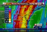
we're talking tides one to three feet. how much rain when this storm is done? i think the model has been doing a good job with this. here's the table. these orange areas are 4-5 inches. here in washington, more than that. south and east though, start to get 8, 10. locally, a foot. that's why flooding will really be a concern. it is going to be a rough day, for sure, with temperatures in the 70s. very heavy rain on and off throughout much of the day. the seven-day forecast, rain tapers to showers tonight. 50s and 60s. 70 for tomorrow. 70 on saturday. looks good by tomorrow afternoon. a nice start next week with highs in the mid-60s. angie, your list has to be as long as mine. >> i know. and unfortunately, we can't get to everything. so we're posting everything for you at www.wusa9.com. let's take a look at the live
8:35 am

shot at our big story here. this collision involved two metro buses. we're told by officials, they were carrying mostly high school students. unfortunately, six of those students were taken to the hospital. we're going get our shot right back and show you the situation from afar. as a result of this, all eastbound lanes remain shut down. police are directing traffic. westbound traffic, they're able to get by. my best suggestion, avoid the area. it looks like this investigation is going to go on for quite some time. 270 headed southbound, we want to take you there. down toward the split, we're looking at an overall drive time of about 33 minutes. no incidents along the way. 495 in maryland, the interloop, is crawling still. making your acrossing that american legion bridge over toward the 270 spur. that accident at old georgetown road is now only blocking one
8:36 am

right lane of traffic, actually the shoulder. more lanes are getting by. hopefully this congestion will start to break part. also between university and georgia avenue up to route 4 at pennsylvania avenue, we have more crashes to keep an eye on. we're looking at more than one hour when it comes to the delay from dale city over to glee. >> thank you, angie. one place we almost always see sandbags with when there's a threat of serious rain is alexandria, virginia. businesses along king street in old town are so close to the waterfront, they're often the first to flood. jessica doyle joins us live. are you seeing sandbags in front of every business there? >> reporter: we are actually not seeing any sandbags, but we might be seeing them in the
8:37 am

next couple days. i want to tell you, we're at very end of king street. i want to introduce to you tony crest, who is the director of communications for the city of alex a alexandria. the problem could be in the next few days. >> we do not expect river flooding here today expect perhaps minor flooding. we're used to that. as the water volume builds over the next few days, the river could be a problem. we'll be keeping close tabs on that. >> reporter: you folks have made sandbags available to residents at king and lee street today. will they continue to be available the nec couple days? >> absolutely. they'll be available as long as people in alexandria need them. we'll replenish them if they run out. >> reporter: what other services are you providing? the rain is really starting to come down. this is what we've been seeing today. what other services is the city
8:38 am

providing in terms of storm cleanage and that sort of business? >> yesterday, we had transportation crews out monitoring the drains and keeping an eye on catch basins, making sure they're clear of debris. they're out there right now and will be on call throughout the day and night to make sure we don't have any street-level flooding because of clogged drains. >> reporter: one final question. you mentioned this is a low- lying elevation. this tends to flood. why are we not seeing sandbags at these particular businesses? >> these particular businesses are familiar and used to the drill here. they keep an eye on the tide. high tide is later this afternoon. i'm sure they'll be paying attention. >> reporter: we appreciate you joining us. we're going to continue to check back in with you over the next couple days, particularly since this river could potentially be a problem coming up on saturday. with that, back to you in the
8:39 am

studio. >> all right. seek shelter, jessica. we'll be here with you throughout the morning. when you can't be here at the television, know that you can log on to www.wusa9.com any time. we'll keep you up to date with storm totals and forecasts, plus you can check the current radar on our home page. there's good news this morning for thousands of nasa workers. that story is coming up. plus the fbi gets a better idea of how much damage the time square bomb could have done. eastbound university looks like we have one lane of traffic getting by at brunette. that's a great update regarding this metro bus accident. over to howard. moderate to heavy rain now moving back into washington and many areas. it's going to be a long, wet day. we'll have an updated forecast when we return.
8:40 am

my dad is the supervisor of a train station and my mom's a teacher. my dad's an auto technician. my mom's a receptionist. i'm not sure i would have been able to afford college without the tuition freeze. while tuition in other states is rising out of reach... governor o'malley made the tough choice to freeze tuition. he made my dream of going to college into a reality. i'm the first in my family to go to college. my brother and i never would have been able to afford college. even though times were tough...
8:41 am

governor o'malley kept his promise. there's never a doubt... there's never a doubt whose side he's on. martin o'malley... moving maryland forward. capital one bank. they're everywhere. yeah, you're right! ♪ [ male announcer ] capital one banks are everywhere. [ clang! ] with hundreds of branches and atms, they're hard to miss. hey, there's one right up the street. [ male announcer ] capital one bank. the most branches and atms in the dc area. what's in your wallet? ove, go long! we are fourteenth in line for take off. beep, beep, beep. looks like its bumper to bumper on the interstate.
8:42 am

i gotta get to cleveland! should have skipped that second soda. remove your belt, your watch, your shoes. i wonder what gas costs today. seven dollars for a pillow! an extra bag costs what? i hate traffic! (train child) the train is now arriving. (announcer) the train has arrived indeed. amtrack. enjoy the journey. in the news now at 8:43,
8:43 am

the fbi tested an explosive device similar to the one attempted to be used in times square. with only a couple shuttle missions left on nasa's schedule, the house voted last night to extend the life of the space shuttle program. the bill also dismantles president bush's plan to return astronauts to the moon. also on capitol hill, overnight, the senate and house passed a temporary spending measure needed to keep federal agencies operating tomorrow when the new budget year starts. most lawmakers are now headed to campaign in their home districts without holding a vote on extending the bush era tax cut. we want to get a check now on flooding conditions in the district. karen joins us on the phone
8:44 am

from d-dot. we spoke with john several hours ago. he said not too many problems. what are we seeing now? >> not too many problems. we do have some concerns, so we still want people to be very, very careful and cautious. virginia avenue is closed at the moment due to flooding. i would suspect that rock creek or beach drive should shut down. those areas we normally hear about that have general flood problem, people should certainly, you know, think about the fact they may be closing at some point during the day. >> karen, we also have been hearing from surrounding jurisdictions that the right side of roadways because of the ponding of water is narrowing streets. are you seeing that in the district as well? >> not so much on the major corridors, but certainly it's something people should be aware of. you drive, you see it. people need to be cautious and careful. go slowly. don't go through high water
8:45 am

levels. turn around, don't drown. you know the national campaign. we want to push the same thing. if the winds pick up or the saturation becomes worse, we have the possibility of downed trees or downed limbs. people should certainly call 311 and report those as soon as possible. we have crews on board all day today and throughout the evening. >> and as we've been talking, a lot of jurisdictions very proactive. had enough advanced warning that these storms were coming. plus, what you went through in late summer, you were prepared. >> absolutely, yes. we have a good team of people here in the district. everyone works very closely together. i think everybody is certainly on aa letter. we're keeping track of things they come in. >> all right. thank you for being with us. howard is here now. when karen was talking about the gusty winds picking up later on today -- >> we're expecting that. >> we could see trees coming
8:46 am

down. we're not getting any word of power outages right now. >> we don't have a loft wind at the moment. we're seeing winds in southeastern virginia, eastern north carolina gusting at 30 miles an hour. i do expect the wind field to expand later on. we could be dealing with those later. with soggy ground, you know the equation. there are still a lot of leaves on the trails. they could be toppling. that storm system is pulling out of north carolina and virginia. we can look at this on the wide picture there on our weather computer. you'll see that red box. that's a tornado watch until 1:00 p.m. we've had isolated tornado warnings here. they still have tornado warnings in eastern north carolina and southeastern virginia. some of the heavier rains also coming into parts of the shenandoah valley. the radar is busy this morning.
8:47 am
we're seeing more yellow showing up across the board as the whole area continues to lift to the north. want to start here in town. we have some moderate rain. you can see it downtown from the mall area right through northwest, up wisconsin avenue through rockville there where 495 and democracy come together. toward the south, it's starting to get heavier. from wood bridge down 495. look at manassas. look at these fingers of heavy, heavy rains. leesberg getting some heavy rain now as well. 66, north of that, it's coming. they just keep coming and coming and coming. wide out picture, this has been the worst of it all day so far. some storm total reports in excess of six inches and climbing over the bay here,
8:48 am
north beach under water there up to annapolis and a the eastern shore. it is coming down. i want to point out western charles county, wood bridge, this area is coming right toward washington. in another 30-60 minutes, i think the rains will really be picking up. back to the weather computer. i want to show you the warnings. these are all flash flood warnings from the northern neck down in the shenandoah over toward the district, up north into maryland. right now, they haven't been extended beyond 10:45, 12:30. about 2:45 out west. you can bet these are going to get extended because we're still expecting a lot more rain. rain potential for this storm, incredible, as we're talk 8 inches plus. maybe 10 inches or a foot. closer to d.c., we look at the orange numbers. up to 7 inches could be
8:49 am
falling. while there's only a little flooding here in washington, more rain will expand as a the rain drains into the low-lying areas. the rest of today, we're talking temperaturessed mid- to upper 70s. it's comfortable here. a very heavy rain at times. a little lightning and thunder. the winds will turn to the southeast and gust up to 30. there's a warm front off to our southeast. you see some of these gusts close to 20, 30-mile-an-hours. devin, some of these storm reports, the totals go up and up and up. >> reporter: they certainly are. here it is on the weather terrace, really starting to come down. heaviest rain i've seen here today. well over an inch of rain has already fallen out here. you've been great all morning
8:50 am

sending your storm reports. middletown, just over an inch of rain since midnight. jim in hughsville says 3.3 inches of rain. st. leonard a, nearly 5 inches of rain. montgomery county, 4 inches of rain. down south in southern maryland, 6.5 inches of rain. again, keep those coming in. if you have photographs of high water, standing water, anything like that, you can send them to us. >> all right. you're talking about the photos. there's one from the national cathedral. the moisture continues to stream in. south carolina is just clearing now. this goes back even a couple hundred miles offshore. you can imagine this flow is going to continue for quite
8:51 am
some time. we've got low pressure coming out of south carolina, now across the north carolina. warm front moving toward us. what's got me a little concerned is that this particular model is trying to develop an area of low pressure that would follow up and enhance the rain overnight. if this happens, it will be bad by tomorrow morning. we're hoping this stays east. this will finally pull away here. friday afternoon looking a lot better. that sets us up for a much nicer weekend ahead. here's our seven-day forecast. the heavy rain and wind today, upper 70s. 74 tomorrow with an early shower. saturday looks good. sunday, could see a passing shower. we cool into the lower 60s. a lot of traffic out there. it's been our top story all morning long. eastbound university at brunette avenue, the accident involving two metro buses. lindsay is on the scene right
8:52 am

now. she just got out of a news conference and has the latest details. >> reporter: we've learned there have been 26 people transported with nonlife threatening injuries to local hospitals. four people do have serious injuries, but again, they're non-life threatening. there were about 40 people object bus, including eight students from montgomery blair high school. there was a school representative out here today to make sure those students were going to be okay. the parents have been notified. >> thank you, lindsay, for that update. eastbound university, we're finally seeing traffic here at brunette avenue able to get by. westbound lanes also are finding their lanes pretty much open. please, if you're going out this way, you're going to want to follow police direction still and use a lot of caution.
8:53 am

just to reiterate it, lindsay said eight of those students were taken to the hospital following that crash involving two metro buses. looking at your outer loop right now in maryland, we are just stacked from 95 over to georgia avenue. on the interloop going the other way, you're going to find yourself in a pretty hefty delay from the american legion bridge to the 270 spur. the bright spot, if there is one, is the accident at georgetown road. you have all your lanes back. 270 headed southbound, no incidents or accidents to report on this roadway. we are looking at an overall a 20-25 minute drive down towards the split. virginia, you're dragging on 66 headed eastbound from 28 to the beltway. that's plus 20 minutes. hour major delay in virginia comes from 95 heading northbound. you're going to find yourself
8:54 am

bumper-to-bumper making your way towards the mixing bowl. it looks this way toward king street. that's a 40 minute to one-hour drive total. 9 news now will be right back. hi. i'm jim perdue.


8:57 am

in case of everyday emergencies... guys, go get changed! ...or soccer practice, it's important to be prepared for dinner. that's why i've prepared my perdue perfect portions fresh chicken breasts. they're individually wrapped, so you can cook what you need and store what you don't. we're not playing helicopter now. ready when you are, they're trimmed of fat and consistently sized to cook in just 10 minutes. life's not perfect. that's why there's perdue perfect portions. [ male announcer ] perdue perfect portions. ready when you are. in entertainment this morning, family fans and costars are mourning tony curtis. he died in los angeles early this morning. manuel has more on his life and legacy. >> reporter: tony curtis knew early on he had charisma. >> i knew there was something different about me.
8:58 am

>> reporter: he was born bernard schwartz in the bronx. he joined the navy when he was 17. when he got out, the g.i. bill paid for acting school. an agent saw him, and curtis was on his way to hollywood. he moved quickly from bit parts to leads in parts like "swashbucklers." ultimately, he appeared in over 100 films, playing diverse roles. in 1958, curtis teamed up with sidney portier in "defiant ones." they both received best actor academy award nominations. nothing was a bigger hit than
8:59 am

the comedy "some like it hot." he plays a musician running from the mob. he was married six times, first to actress janet lee, the mother of jamie lee curtis, the only one of his six children to enter show business. curtis loved to paint and credited his art with helping him through a period of addiction to alcohol and cocaine in the 70s. as much as he loved standing in front of an easel, nothing gave him more pleasure than standing in front of an audience. and thank you for watching 9 news now. it is 9:00 a.m. i'm joined by leslie foster. >> after five straight hours on the air, we figured you might want a break. thank you for joining us this morning. boy, have you been busy. >> yeah, we've been busy all morning thanks to
285 Views
IN COLLECTIONS
WUSA (CBS) Television Archive
  Television Archive News Search Service
Uploaded by TV Archive on
